The Unique Maps Co.
Old Map of Woodside, California by USGS, 1953 – Stanford University, Portola Valley & San Francisco Bay
Old Map of Woodside, California by USGS, 1953 – Stanford University, Portola Valley & San Francisco Bay
Couldn't load pickup availability
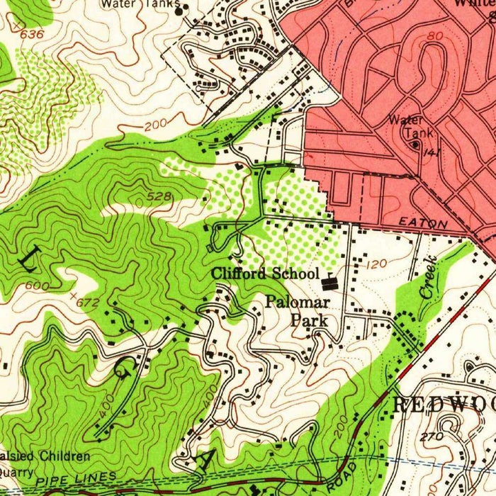
Published in 1960 from 1953 survey data, the USGS map titled “Woodside” captures a poised moment in the mid-century Peninsula, before the full force of Silicon Valley growth transformed its orchards, estates, campuses, and wooded canyons. Centered on Woodside, California, the map extends across a landscape where the cultivated order of roads and settlements meets the steep, folded terrain of the Coast Range foothills. Its 1:24,000 scale offers an intimate topographical portrait: houses, trails, streams, ridgelines, and valleys are rendered with the precision for which the U.S. Geological Survey became famous. The result is both a scientific document and a richly atmospheric view of a California landscape balanced between rural seclusion and metropolitan expansion.
Woodside itself appears as a historic Peninsula community embedded in a terrain of hills, ravines, and shaded slopes. Long associated with redwood forests, ranch estates, and equestrian culture, the town occupies a transitional zone between the San Francisco Bay lowlands and the rising Santa Cruz Mountains. The map’s dense contour lines reveal the dramatic local relief: gentle valley floors quickly give way to steeper wooded inclines, with roads bending and climbing in response to the land. Green shading marks areas of vegetation, emphasizing the wooded character that has long distinguished Woodside from the more urbanized communities nearby. In this cartographic setting, the town reads not as an isolated settlement, but as part of a broader landscape of creeks, ridges, and open ground.
The map’s wider geography links Woodside to some of the defining landmarks of the mid-Peninsula. Stanford University lies nearby, anchoring the cultural and educational landscape to the south and east, while the presence of San Francisco Bay in the vicinity situates the map within one of California’s most important regional corridors. Bay Meadows and surrounding communities hint at the increasingly developed edge of the Peninsula, where transportation routes, suburban growth, and recreational sites were reshaping the area in the postwar years. Portola Valley and the nearby hills introduce a quieter, more rural counterpoint. Together, these places show a region in transition: academic, residential, agricultural, and natural landscapes overlapping before later decades of intensified development.
As a work of topographic design, the “Woodside” map is especially compelling for its contouring. Closely spaced lines articulate steep slopes and narrow valleys, while broader intervals indicate gentler ground, allowing the viewer to read elevation almost as texture. The USGS color scheme is restrained but effective: green areas suggest vegetation and wooded terrain, while lighter zones distinguish clearer ground, developed areas, or more open landscapes. Roads, trails, streams, and water bodies are carefully integrated into this relief model, making the map both practical and visually absorbing. It is a landscape of movement and constraint, where every route must negotiate ridges, drainage lines, and hillside gradients, revealing the intimate relationship between settlement and terrain.
Historically, this map is a valuable snapshot of the Peninsula in the 1950s, a period when older rural patterns still remained visible even as suburban and institutional expansion accelerated around San Francisco Bay. The roads and trails record access routes before later realignments; the wooded areas and open spaces preserve evidence of a landscape that would face pressure from development, fire management, conservation policy, and changing land use. Parks and natural reserves in and around the mapped area point toward the region’s growing environmental significance, particularly along the foothills and valley corridors. Today, the map invites comparison between past and present, offering a beautifully detailed record of Woodside and its surroundings at a pivotal moment in California’s modern history.
Cities, towns and places on this map
- Woodside, California
- Stanford University
- San Francisco Bay
- Bay Meadows
- Portola Valley
- Nearby hills and valleys
- Various trails and roads
- Streams and rivers
- Parks and natural reserves
Historical context & cartographic details
- Historical 1:24,000 topographical map titled Woodside
- Dated 1953, with a 1960 imprint
- Produced by the US Geological Survey (USGS)
- Shows the area as it appeared in the 1950s, capturing land use and natural features before later changes from urban development, environmental policy, and natural events such as wildfires
- Features detailed contour lines to represent elevation and landforms
- Closely spaced contour lines indicate steep terrain and significant topographic variation
- Uses green coloration to indicate vegetation and terrain
- White areas likely represent clear ground or lower elevations
- Illustrates rugged Californian terrain characterized by hills and valleys
Looking for a particular place? Review the detailed images to confirm that the town, landmark or feature you have in mind appears on the map. If you are unsure, ask our workshop to check before you order.
Detailed maps are especially rewarding at larger sizes, where names, boundaries and decorative features have more room to be appreciated. Use the close-up preview and size guide to choose the right scale for your wall.
This map looks amazing at sizes all the way up to 50in (125cm). If you are looking for a larger map, please get in touch.
The model in the listing images is holding the 16x20in (40x50cm) version of this map.
Where personalisation is available, you can add a short title or dedication, mark one meaningful place, or request one considered visual detail. See personalised map examples.
Every piece is printed to museum-grade archival standards using fade-resistant pigment inks on acid-free matte paper. Choose an unframed map print, framed map or canvas using the finish options above. Framed maps use crystal-clear optical acrylic and arrive ready to hang.
With its rich detail and strong sense of place, this map makes a considered gift for a new home, anniversary, retirement or anyone with a personal connection to the area shown. Still deciding? Explore our collection of rare old and vintage maps to discover another place, period or style.
Share