The Unique Maps Co.
Old Map of Stone Harbor, New Jersey by USGS, 1894 – Dennisville, Great Sound & Delaware Bay
Old Map of Stone Harbor, New Jersey by USGS, 1894 – Dennisville, Great Sound & Delaware Bay
Couldn't load pickup availability
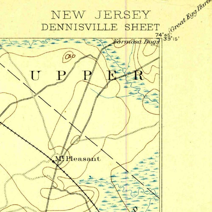
Published in 1899 from survey data collected in 1894, the U.S. Geological Survey’s “Dennisville” captures a revealing stretch of southern New Jersey at a moment when its coastal landscapes were still being measured, classified, and transformed. Issued under the direction of J. W. Powell, the map belongs to the great national project of late nineteenth-century scientific cartography: rendering the United States in systematic topographic form. At a scale of 1:62,500, it balances regional scope with local precision, presenting Dennisville, Stone Harbor, the Great Sound, and the intricate margins of Delaware Bay with disciplined clarity. Its delicate light-blue treatment of water lends the sheet an elegant coastal character, while contour lines and crisp labels translate marsh, upland, creek, road, and rail into a highly legible geographic portrait.
Stone Harbor, now known as a refined seaside resort, appears here within a broader world of barrier beaches, tidal channels, sounds, and wetlands. The map’s depiction of Great Sound and the surrounding marshlands evokes the mutable geography of the New Jersey shore, where land and water interlace in a constantly shifting pattern. Creeks such as Green Creek thread through low-lying terrain, feeding a landscape shaped by tide, sediment, and salt-marsh ecology. The cartography makes plain how different this coast was before the full force of twentieth-century resort development: a place of waterways, islands, and rural settlements, only gradually being connected by improved roads and rail lines. For collectors, it offers a rare geographic baseline for understanding the evolution of Cape May County’s shore communities.
Dennisville itself anchors the inland portion of the map, set amid the roads, waterways, and wooded lowlands of southern New Jersey. Nearby Cedar Swamp suggests the ecological richness that once defined much of the region, where forested wetlands, agricultural clearings, and tidal marsh formed a varied coastal hinterland. Lower Township and Upper Township appear as part of a broader civic framework, their boundaries and routes helping to organize the map’s otherwise natural complexity. The Maurice River and Delaware Bay give the sheet a westward hydrological grandeur, linking local creeks and settlements to larger systems of navigation, trade, and estuarine life. In this respect, the map is not merely a record of places, but a study in relationships: between inland villages, coastal margins, and the bay beyond.
The design reflects the refined conventions of late nineteenth-century American topographic mapping. Contour lines provide a subtle but essential reading of elevation across a region where even slight rises could determine settlement, drainage, and road placement. Water is rendered in pale blue, a graceful contrast to the fine black linework of roads, railways, boundaries, and place names. Dashed and solid linear symbols distinguish the infrastructure of movement across marsh and countryside, revealing how transportation networks were beginning to knit together rural townships and emerging seaside destinations such as Anglesea and Stone Harbor. The result is a map of scientific restraint and quiet beauty, where every symbol serves both measurement and visual harmony.
Historically, “Dennisville” is especially valuable for what it reveals about land use and environmental change along the New Jersey coast. Its marshes, creeks, and barrier formations preserve a cartographic memory of landscapes later altered by dredging, development, causeways, resort building, and changing shoreline management. At the same time, it reflects the ambitions of the U.S. Geological Survey under Powell’s intellectual legacy: to map the nation not as a patchwork of local impressions, but as a coherent physical landscape governed by geology, elevation, hydrology, and settlement. For Stone Harbor and its neighboring communities, the map offers a compelling view before modern density, when the coast was still defined by open wetlands, tidal passages, and the measured precision of a young scientific republic.
Cities, towns and places on this map
- Stone Harbor
- Dennisville
- Maurice River
- Cedar Swamp
- Great Sound
- Delaware Bay
- Lower Township
- Upper Township
- Anglesea
- Green Creek and other creeks
- Coastlines and marshlands along the New Jersey shore
- Roadways and railways throughout the area
Historical context & cartographic details
- Published by the U.S. Geological Survey under the direction of J. W. Powell.
- Data was collected in 1894 and the map was published in 1899.
- Historical topographical map at a scale of 1:62,500.
- Depicts Stone Harbor and surrounding areas in New Jersey.
- Light blue shading is used to represent water bodies and emphasize coastal areas.
- Contour lines show elevation changes and support the map’s topographical detail.
- Reflects late 19th-century cartographic practices, with clear labeling and structured detail.
- Shows elevations, marshlands, and coastal features typical of the New Jersey shoreline.
- Provides insight into late 19th-century land use, coastal development, ecology, and geographic understanding.
Looking for a particular place? Review the detailed images to confirm that the town, landmark or feature you have in mind appears on the map. If you are unsure, ask our workshop to check before you order.
Detailed maps are especially rewarding at larger sizes, where names, boundaries and decorative features have more room to be appreciated. Use the close-up preview and size guide to choose the right scale for your wall.
This map looks amazing at sizes all the way up to 50in (125cm). If you are looking for a larger map, please get in touch.
The model in the listing images is holding the 16x20in (40x50cm) version of this map.
Where personalisation is available, you can add a short title or dedication, mark one meaningful place, or request one considered visual detail. See personalised map examples.
Every piece is printed to museum-grade archival standards using fade-resistant pigment inks on acid-free matte paper. Choose an unframed map print, framed map or canvas using the finish options above. Framed maps use crystal-clear optical acrylic and arrive ready to hang.
With its rich detail and strong sense of place, this map makes a considered gift for a new home, anniversary, retirement or anyone with a personal connection to the area shown. Still deciding? Explore our collection of rare old and vintage maps to discover another place, period or style.
Share