The Unique Maps Co.
Old Map of Piedmont, California by USGS, 1949 – Oakland, San Francisco Bay & Grizzly Peak
Old Map of Piedmont, California by USGS, 1949 – Oakland, San Francisco Bay & Grizzly Peak
Couldn't load pickup availability
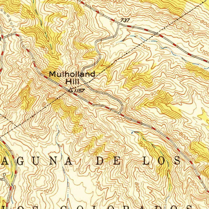
The 1949 United States Geological Survey map titled “Oakland East” captures a richly textured portion of the East Bay at a moment of postwar transition. Centered on Piedmont, California, and extending across Oakland’s eastern neighborhoods toward the ridges above San Francisco Bay, the map presents both the precision of federal science and the quiet drama of a rapidly urbanizing landscape. At the 1:24,000 scale, it renders streets, parks, creeks, reservoirs, and relief with unusual clarity, allowing the viewer to read the area as both city and terrain. The detailed grid of Oakland’s expanding neighborhoods contrasts beautifully with the rising contours of the Berkeley and Oakland hills, making the map a fascinating record of land use, movement, and settlement in the late 1940s.
The USGS, founded in 1879, became the authoritative cartographic voice for the American landscape, producing maps intended for engineers, planners, scientists, and the public. “Oakland East” belongs to that tradition of rigorous observation: roads are crisply delineated, institutional grounds and parks are identified, and the geometry of urban streets is set against the organic sweep of ravines and ridgelines. Its color gradients and closely spaced contour lines give the map a dimensional quality, revealing the steepness of slopes and the complex topography that defines the East Bay. This is not merely a street plan, but a scientific portrait of place, designed to show how human settlement occupies, negotiates, and sometimes presses against the natural form of the land.
Piedmont appears here as an enclave of carefully ordered streets and residential development, surrounded by the larger fabric of Oakland. By 1949, the East Bay was being reshaped by wartime industry, postwar housing demand, automobile mobility, and expanding suburban aspirations. The map preserves that moment before later waves of freeway construction and metropolitan intensification would further transform the region. Oakland’s street grids, civic spaces, and parklands are shown with precision, while the nearby hills remind us that this urban environment was built across challenging terrain. For collectors interested in California urban history, the map offers a compelling view of how neighborhoods, roads, and open spaces were arranged in the years just after the Second World War.
The natural features depicted are especially evocative. Grizzly Peak rises along the eastern heights, part of the commanding ridge system that separates the bay-facing cities from the inland valleys. Lake Temescal, Temescal Creek, and San Pablo Reservoir speak to the hydrology of the region, where watercourses and reservoirs shaped both settlement and recreation. Redwood Park and Tilden Regional Park mark the importance of preserved open land within reach of dense urban districts, reflecting a regional vision in which wilderness, leisure, and city life coexist. The contour work surrounding these places gives a strong impression of folded hills, wooded canyons, and elevated viewpoints overlooking San Francisco Bay.
As a historical object, “Oakland East” is particularly valuable for the way it combines everyday detail with broader geographic meaning. Streets and roads appear in disciplined patterns, yet they are interrupted and redirected by creeks, slopes, parks, and reservoirs. This interplay reveals the physical logic behind the East Bay’s growth: urban development followed flatter corridors while the hills retained a more rugged, park-like character. The map is also a visual archive of late-1940s infrastructure, neighborhood form, and public land, preserving a landscape on the cusp of modern metropolitan expansion. Elegant in its restraint and exacting in its information, it invites close study as both a cartographic document and a portrait of Piedmont and Oakland’s enduring relationship with their dramatic terrain.
Cities, towns and places on this map
- Piedmont
- Oakland
- San Francisco Bay
- Grizzly Peak
- Redwood Park
- Tilden Regional Park
- Lake Temescal
- San Pablo Reservoir
- Temescal Creek
- Various streets and roads marked in grid patterns
- Institutional buildings and parks indicated within the urban layout
Historical context & cartographic details
- Produced by the United States Geological Survey as a historical 1:24,000 topographical map of Piedmont, California and the surrounding area
- Created in 1949
- Published by the United States Geological Survey (USGS), a U.S. government scientific agency responsible for studying landscapes, natural resources, and natural hazards
- Uses distinct color gradients to represent elevation changes, giving the terrain a three-dimensional feel
- Features a detailed grid overlay characteristic of USGS topographical maps
- Shows varied elevation, including urban areas and expansive hilly or mountainous regions
- Uses contour lines to indicate the steepness of slopes and clarify the geography
- Reflects the landscape and urban development of the late 1940s, including changes around Piedmont in urban sprawl and land use
Looking for a particular place? Review the detailed images to confirm that the town, landmark or feature you have in mind appears on the map. If you are unsure, ask our workshop to check before you order.
Detailed maps are especially rewarding at larger sizes, where names, boundaries and decorative features have more room to be appreciated. Use the close-up preview and size guide to choose the right scale for your wall.
This map looks amazing at sizes all the way up to 50in (125cm). If you are looking for a larger map, please get in touch.
The model in the listing images is holding the 16x20in (40x50cm) version of this map.
Where personalisation is available, you can add a short title or dedication, mark one meaningful place, or request one considered visual detail. See personalised map examples.
Every piece is printed to museum-grade archival standards using fade-resistant pigment inks on acid-free matte paper. Choose an unframed map print, framed map or canvas using the finish options above. Framed maps use crystal-clear optical acrylic and arrive ready to hang.
With its rich detail and strong sense of place, this map makes a considered gift for a new home, anniversary, retirement or anyone with a personal connection to the area shown. Still deciding? Explore our collection of rare old and vintage maps to discover another place, period or style.
Share