The Unique Maps Co.
Old Map of Palo Alto, California by USGS, 1961 – Stanford University, Menlo Park & Los Altos Hills
Old Map of Palo Alto, California by USGS, 1961 – Stanford University, Menlo Park & Los Altos Hills
Couldn't load pickup availability
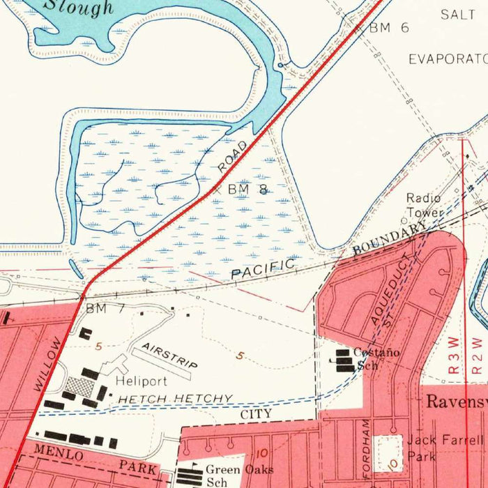
The map titled “Palo Alto” was created by the United States Geological Survey in 1961 and published in 1965, presenting the mid-Peninsula at the highly legible 1:24,000 topographic scale. It captures Palo Alto and its neighboring communities at a pivotal moment, just before the region’s transformation into the globally recognized heart of Silicon Valley. Stanford University, Menlo Park, Los Altos Hills, Portola Valley, Atherton, and nearby portions of Redwood City appear within a landscape still balanced between campus, suburb, orchard, hillside, and bayland. As a historical document, it preserves the area’s early-1960s settlement pattern, showing a refined cartographic portrait of a region on the threshold of extraordinary technological and urban change.
The US Geological Survey’s disciplined cartographic language gives this map both scientific authority and visual elegance. Its color system distinguishes built-up areas, cultivated or open land, wooded slopes, water features, and engineered landscapes, allowing the viewer to read land use almost at a glance. Contour lines articulate the terrain with precision, especially where the flatlands of Palo Alto and Menlo Park begin to rise toward Los Altos Hills and Portola Valley. Roads, rail corridors, institutional grounds, residential neighborhoods, and water bodies are all carefully integrated into the sheet. The result is a map that is not merely descriptive but analytical, revealing how geology, settlement, transportation, and land development interacted across the Peninsula.
One of the map’s most compelling features is its dramatic transition from the low, level margins of San Francisco Bay to the rolling foothills of the Santa Cruz Mountains. Salt evaporation ponds and bay-adjacent wetlands speak to the industrial and ecological history of the shoreline, while the contoured uplands to the west describe a very different landscape of ridges, valleys, and scattered development. Portola Valley and Los Altos Hills appear in a more spacious, topographically complex setting than the gridded urban fabric closer to the bay. This contrast gives the map unusual depth: it records not only places, but the physical forces that shaped their growth.
Palo Alto itself is shown as a cultivated urban center, anchored by its relationship to Stanford University and the surrounding communities of Menlo Park and Atherton. In the early 1960s, this was already a region of research, education, and affluent residential expansion, but it had not yet acquired the dense technological identity that would later define it. The map therefore offers a fascinating pre-boom view of the Peninsula, where railways, arterial roads, neighborhoods, campus lands, and open spaces form a measured and comparatively spacious pattern. For collectors interested in Silicon Valley’s origins, it is a particularly evocative record of the landscape before rapid corporate and infrastructural acceleration.
Beyond its local interest, this map is a study in the evolution of American suburban geography. It shows communities that would soon become internationally famous still embedded in a visibly varied terrain of baylands, foothills, institutional estates, residential tracts, and semi-rural margins. The presence of open spaces, parks, water features, and undeveloped hillsides underscores how much the region’s later growth depended upon—and competed with—its natural setting. As a historical snapshot, the “Palo Alto” quadrangle preserves the Peninsula at a rare moment of balance: modern enough to show the outlines of the future, yet early enough to retain the textures of an older California landscape.
Cities, towns and places on this map
- Palo Alto
- Menlo Park
- Los Altos Hills
- Portola Valley
- Stanford University
- Redwood City
- Atherton
- Various residential neighborhoods
- Salt evaporation ponds
- Open spaces and parks
- Roads and highways
- Railways
- Water bodies, including lakes and rivers
- Contoured land features, including hills and valleys
Historical context & cartographic details
- Produced by the US Geological Survey (USGS)
- Created in 1961 and published in 1965
- Historical 1:24,000 topographical map incorporating survey data from the Palo Alto area and neighboring locales
- Accurately represents incorporated regions around Palo Alto during the early 1960s
- Shows Palo Alto’s proximity to Stanford University and its later significance within Silicon Valley
- Uses detailed color coding to distinguish urban, agricultural, and forested areas
- Includes contours and relief shading to show elevation changes and terrain
- Presents a mix of urban and natural landscapes with notable topographical variation
- Serves as a historical snapshot of early-1960s land use patterns and infrastructure before later urban development and growth
Looking for a particular place? Review the detailed images to confirm that the town, landmark or feature you have in mind appears on the map. If you are unsure, ask our workshop to check before you order.
Detailed maps are especially rewarding at larger sizes, where names, boundaries and decorative features have more room to be appreciated. Use the close-up preview and size guide to choose the right scale for your wall.
This map looks amazing at sizes all the way up to 50in (125cm). If you are looking for a larger map, please get in touch.
The model in the listing images is holding the 16x20in (40x50cm) version of this map.
Where personalisation is available, you can add a short title or dedication, mark one meaningful place, or request one considered visual detail. See personalised map examples.
Every piece is printed to museum-grade archival standards using fade-resistant pigment inks on acid-free matte paper. Choose an unframed map print, framed map or canvas using the finish options above. Framed maps use crystal-clear optical acrylic and arrive ready to hang.
With its rich detail and strong sense of place, this map makes a considered gift for a new home, anniversary, retirement or anyone with a personal connection to the area shown. Still deciding? Explore our collection of rare old and vintage maps to discover another place, period or style.
Share