The Unique Maps Co.
Old Map of Oceanside, California by USGS, 1947 – Camp Pendleton, San Luis Rey River & Pacific Ocean
Old Map of Oceanside, California by USGS, 1947 – Camp Pendleton, San Luis Rey River & Pacific Ocean
Couldn't load pickup availability
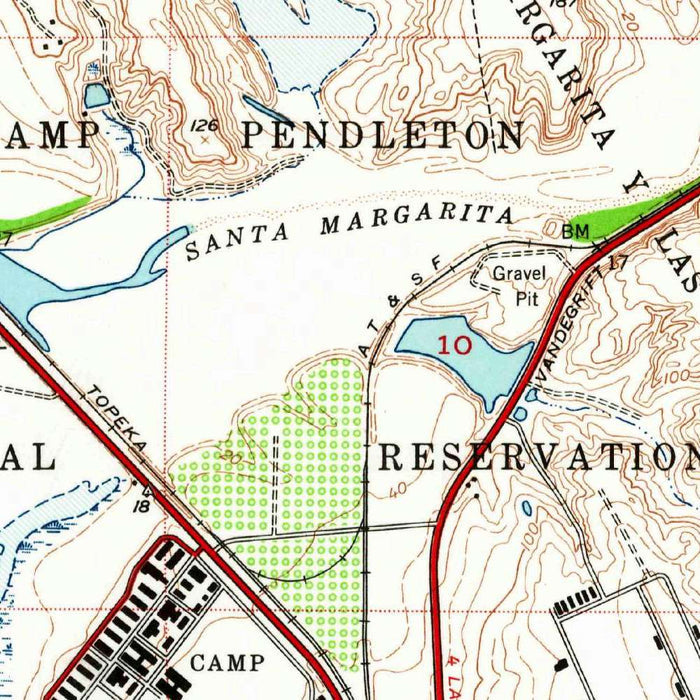
The “Oceanside Quadrangle” captures a revealing moment on the Southern California coast: data collected in 1947, yet published by the United States Geological Survey in 1962, when postwar growth was rapidly reshaping San Diego County. At a detailed 1:24,000 scale, the map presents Oceanside, the Pacific shoreline, the San Luis Rey River, and the adjoining military lands of Camp Pendleton with the precision for which USGS quadrangles are renowned. Its topographic language is both practical and elegant: contours articulate the gentle rises and inland slopes behind the coast, while the ocean edge, roads, reservations, and settled areas form a layered portrait of a community poised between beach town, transportation corridor, and military neighbor.
Created by the US Geological Survey, this map belongs to one of the great scientific mapping traditions in American history. Founded to study the nation’s geology, hydrology, and geography, the USGS became the principal authority for topographic mapping across the United States, translating field observations and survey measurements into standardized, richly informative quadrangles. Here, that discipline is evident in the careful delineation of elevations, drainage, transportation routes, and land use. The result is not merely a location map, but a measured landscape—one that allows the viewer to read the ground itself. Oceanside’s streets, the coastal plain, and the river corridor are arranged with the quiet authority of a document made for engineers, planners, military users, and explorers alike.
Oceanside appears as the map’s central coastal presence, set against the broad blue expanse of the Pacific Ocean. Long known for its beaches, harbor life, and easy relationship with the sea, the city occupies a strategic position along the Southern California shoreline north of San Diego. The map records the coastal areas surrounding Oceanside before much of the later suburban expansion transformed open tracts into neighborhoods, commercial corridors, and modern infrastructure. Roads and highways trace the connective tissue of the region, linking local communities with San Diego County and the broader coast. In this mapped moment, Oceanside is both established and still visibly emerging, a city whose postwar future was beginning to take shape.
To the north and east, Camp Pendleton gives the quadrangle exceptional historical resonance. Established during the Second World War, the Marine Corps base became one of the most important military installations on the West Coast, shaping the economy, mobility, and identity of the Oceanside area. The presence of military and naval reservation lands on the map underscores how closely civilian settlement and national defense overlapped in mid-twentieth-century Southern California. Boundaries, roads, and open terrain hint at a landscape managed for training, movement, and security, contrasting with the denser coastal community nearby. This juxtaposition—resort shoreline, growing city, river valley, and military reservation—makes the map a particularly vivid record of postwar regional geography.
The San Luis Rey River is one of the map’s defining natural features, cutting through the coastal plain on its way toward the Pacific and anchoring the inland topography around Oceanside. Contour lines reveal subtle changes in elevation along the coast and more pronounced rises inland, offering a clear sense of how water, settlement, and transportation followed the land. The cartographic design uses color to clarify this landscape: blues emphasize the ocean and waterways, while greens and browns distinguish terrain and elevation. As a historical document, the map preserves a San Diego County coastline before decades of intensified development, population growth, expanded highways, and changing land use altered the visual and physical character of the region.
Cities, towns and places on this map
- Oceanside
- Camp Pendleton
- San Luis Rey River
- Pacific Ocean
- San Diego County
- Coastal areas surrounding Oceanside
- Neighborhoods within Oceanside
- US Naval Reservation
- Various roads and highways connecting the area
- Points of elevation along the coastline and inland regions
Historical context & cartographic details
- Historical 1:24,000 topographical map of Oceanside, California and the surrounding area
- Produced by the US Geological Survey
- Data collected in 1947 and published in 1962
- Shows terrain features, infrastructure, and significant landmarks
- Uses vibrant colors to differentiate landforms and water bodies
- Blue hues indicate the Pacific Ocean and waterways
- Greens and browns represent land elevations
- Contour lines depict elevation changes and topographic character
- The 1:24,000 scale allows for detailed examination of the landscape
- The area has undergone substantial urban development, land-use changes, population growth, and infrastructure expansion since the map was created
Looking for a particular place? Review the detailed images to confirm that the town, landmark or feature you have in mind appears on the map. If you are unsure, ask our workshop to check before you order.
Detailed maps are especially rewarding at larger sizes, where names, boundaries and decorative features have more room to be appreciated. Use the close-up preview and size guide to choose the right scale for your wall.
This map looks amazing at sizes all the way up to 50in (125cm). If you are looking for a larger map, please get in touch.
The model in the listing images is holding the 16x20in (40x50cm) version of this map.
Where personalisation is available, you can add a short title or dedication, mark one meaningful place, or request one considered visual detail. See personalised map examples.
Every piece is printed to museum-grade archival standards using fade-resistant pigment inks on acid-free matte paper. Choose an unframed map print, framed map or canvas using the finish options above. Framed maps use crystal-clear optical acrylic and arrive ready to hang.
With its rich detail and strong sense of place, this map makes a considered gift for a new home, anniversary, retirement or anyone with a personal connection to the area shown. Still deciding? Explore our collection of rare old and vintage maps to discover another place, period or style.
Share