The Unique Maps Co.
Old Map of New Haven, Connecticut by USGS, 1954 – New Haven Harbor & Long Island Sound
Old Map of New Haven, Connecticut by USGS, 1954 – New Haven Harbor & Long Island Sound
Couldn't load pickup availability
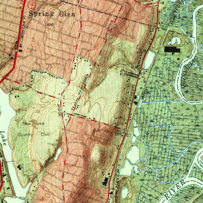
Published in 1956 from survey data gathered in 1954, “New Haven” is a finely observed US Geological Survey portrait of one of Connecticut’s most historically layered coastal cities. At a scale of 1:31,680, it captures New Haven at a moment when postwar infrastructure, expanding neighborhoods, and older maritime patterns coexisted across a varied landscape. The city is set beside New Haven Harbor and Long Island Sound, with roads, waterways, parks, and urban districts carefully integrated into the surrounding topography. The map’s shaded relief gives particular drama to the scene, making the hills and valleys around the city legible at a glance. More than a civic plan, it is a mid-century geographical record of how New Haven occupied its harbor, plain, and upland setting.
The US Geological Survey brought to this map the precision and clarity for which its topographic work became indispensable to planners, engineers, educators, and explorers. Produced, edited, and published by the USGS, the sheet reflects a federal mapping tradition rooted in careful field survey, standardized symbols, and an insistence that natural and built environments be read together. In New Haven, that union is especially compelling: the street network and developed neighborhoods sit within a landscape shaped by ridges, streams, tidal waters, and valleys. The map’s disciplined cartographic language allows the viewer to move easily from the dense urban core to the surrounding terrain, revealing how geography influenced circulation, settlement, and the growth of the city.
The shaded relief is one of the map’s most evocative features, transforming the New Haven region from a flat diagram into a textured landscape of slopes, heights, and depressions. Color gradation and shadowing emphasize the rugged ground beyond the city’s harbor-edge neighborhoods, where hills rise from the coastal plain and valleys open routes inland. This style makes the terrain immediately comprehensible, showing why roads bend, neighborhoods cluster, and open spaces survive in particular locations. Around New Haven, the land is not merely background; it shapes the city’s form. The relief treatment also gives the map a visual richness that distinguishes it from more purely utilitarian urban mapping, offering both technical information and an atmospheric sense of place.
New Haven Harbor and Long Island Sound anchor the southern portion of the composition, underscoring the city’s enduring relationship with maritime commerce, tidal waters, and the broader Atlantic world. The harbor’s presence helps explain New Haven’s historical growth as a port, while the adjacent urban grid reflects centuries of development radiating from the old town center. Roads and highways mark the mid-20th-century transformation of movement through the region, capturing a period when automobile infrastructure was becoming increasingly central to American urban life. Rivers and smaller waterways thread through the map, linking upland drainage to the coast. Parks and natural features appear as important counterpoints to the built environment, preserving traces of the older landscape within and around the city.
As a historical document, this map preserves New Haven just before later decades of urban renewal, highway construction, suburban expansion, and changing land use reshaped much of the region. It offers a valuable view of neighborhoods, transportation corridors, harbor margins, and surrounding open land as they appeared in the 1950s. For anyone interested in Yale’s city, Connecticut’s shoreline, or the broader evolution of American urban landscapes, the map rewards close reading: each contour, road, and watercourse contributes to a layered story of settlement and terrain. Its careful balance of scientific accuracy and visual elegance makes it an especially compelling record of New Haven’s mid-century geography, where coastal industry, civic life, and rugged New England topography meet.
Cities, towns and places on this map
- New Haven
- New Haven Harbor
- Long Island Sound
- Various neighborhoods within New Haven
- Surrounding hills and valleys
- Roads, including major streets and highways
- Rivers and waterways
- Parks and natural features
- Notable landmarks within the urban landscape
Historical context & cartographic details
- Produced, edited, and published by the US Geological Survey (USGS)
- Survey data from 1954, with publication in 1956
- Scale: 1:31,680
- Includes shaded relief to emphasize elevation changes and topographical features through color gradation and shadows
- Shows the rugged terrain surrounding New Haven, including hills and valleys
- Reflects the New Haven area as it existed in the mid-20th century
- Useful for understanding urban development, land-use change, and historical geography in the New Haven area
Looking for a particular place? Review the detailed images to confirm that the town, landmark or feature you have in mind appears on the map. If you are unsure, ask our workshop to check before you order.
Detailed maps are especially rewarding at larger sizes, where names, boundaries and decorative features have more room to be appreciated. Use the close-up preview and size guide to choose the right scale for your wall.
This map looks amazing at sizes all the way up to 50in (125cm). If you are looking for a larger map, please get in touch.
The model in the listing images is holding the 16x20in (40x50cm) version of this map.
Where personalisation is available, you can add a short title or dedication, mark one meaningful place, or request one considered visual detail. See personalised map examples.
Every piece is printed to museum-grade archival standards using fade-resistant pigment inks on acid-free matte paper. Choose an unframed map print, framed map or canvas using the finish options above. Framed maps use crystal-clear optical acrylic and arrive ready to hang.
With its rich detail and strong sense of place, this map makes a considered gift for a new home, anniversary, retirement or anyone with a personal connection to the area shown. Still deciding? Explore our collection of rare old and vintage maps to discover another place, period or style.
Share