The Unique Maps Co.
Old Map of Montrose, Colorado by USGS, 1962 – Uncompahgre River, Black Canyon & San Juan Mountains
Old Map of Montrose, Colorado by USGS, 1962 – Uncompahgre River, Black Canyon & San Juan Mountains
Couldn't load pickup availability
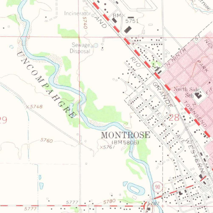
“Montrose West” is a U.S. Geological Survey topographical map of western Montrose, Colorado, published in 1974 using survey data collected in 1962. At the 1:24,000 scale, it captures the city and its immediate surroundings at a moment when this southwestern Colorado community was both a working agricultural center and an increasingly important regional gateway. The map records streets, roads, trails, drainage patterns, and landforms with the precision characteristic of USGS quadrangles. Its historical value lies in this exactness: the Montrose shown here predates decades of suburban expansion, infrastructure change, and evolving land use, preserving the landscape as it appeared in the early 1960s.
The U.S. Geological Survey brought to this map nearly a century of institutional experience in measuring and depicting the American landscape. Founded in 1879, the USGS became the nation’s authoritative source for topographic mapping, producing quadrangles that served engineers, planners, geologists, land managers, and travelers alike. “Montrose West” reflects that disciplined cartographic tradition: clean typography, carefully differentiated road classifications, hydrographic detail, and contour lines that translate terrain into a readable visual language. Rather than presenting the region as a scenic abstraction, the map offers a practical, scientific portrait of place—one rooted in field survey, aerial interpretation, and the meticulous standardization that made USGS maps indispensable.
The topographic character of the Montrose area is central to the map’s appeal. Contour lines reveal the subtle and dramatic changes in elevation that define this part of western Colorado, where river valleys, mesas, foothills, and distant mountain systems meet. The Uncompahgre River, a defining natural feature of the region, helps organize the landscape, its course accompanied by irrigated lands, transportation corridors, and settlement. Nearby drainages and unnamed valleys show how water shaped both the terrain and human occupation. The map’s color scheme distinguishes vegetation, built areas, water, and relief, allowing the viewer to read not only elevation but also the lived geography of the place.
Montrose occupies a strategic position between some of Colorado’s most celebrated natural regions. To the south rise the San Juan Mountains, long associated with mining, alpine exploration, and rugged scenic grandeur. To the northeast and east, the Gunnison country leads toward the Black Canyon of the Gunnison, one of the most dramatic river-carved landscapes in the American West. The broader regional setting also connects Montrose to features such as the Gunnison River, Blue Mesa Reservoir, and the Owl Creek Mountains. Within this context, the map is more than a local plan: it situates Montrose within a high-country network of rivers, uplands, canyons, and routes.
As a historical document, “Montrose West” offers a fascinating view of a community and landscape in transition. Roads and trails trace patterns of movement before later development reshaped the area, while the arrangement of fields, waterways, and built-up zones speaks to Montrose’s agricultural foundations and regional importance. The early 1960s were a period when many Western towns were balancing traditional land uses with new recreational, infrastructural, and residential pressures. This map captures that balance with quiet authority. For collectors of Colorado history, Western topography, or USGS cartography, it provides an elegant and data-rich window into the geography of Montrose at a pivotal moment.
Cities, towns and places on this map
- Montrose, Colorado
- Uncompahgre River
- Gunnison River
- Blue Mesa Reservoir
- San Juan Mountains
- Black Canyon of the Gunnison National Park
- Owl Creek Mountains
- Several unnamed valleys and peaks
- Various roads and trails in the region
Historical context & cartographic details
- Historical 1:24,000 topographical map produced by the U.S. Geological Survey.
- Original survey data was collected in 1962 and the map was published with a 1974 imprint.
- The USGS is known for reliable topographical mapping and surveying across the United States.
- Uses standard topographical design, including contour lines to show elevation.
- Features a color palette indicating different terrains and vegetation.
- Shaded relief helps convey the character of the landscape.
- Shows significant elevation changes typical of mountainous terrain.
- Reflects the area’s geographic and infrastructural state in the early 1960s.
- Useful for comparing later development, land use changes, and environmental changes over time.
Looking for a particular place? Review the detailed images to confirm that the town, landmark or feature you have in mind appears on the map. If you are unsure, ask our workshop to check before you order.
Detailed maps are especially rewarding at larger sizes, where names, boundaries and decorative features have more room to be appreciated. Use the close-up preview and size guide to choose the right scale for your wall.
This map looks amazing at sizes all the way up to 50in (125cm). If you are looking for a larger map, please get in touch.
The model in the listing images is holding the 16x20in (40x50cm) version of this map.
Where personalisation is available, you can add a short title or dedication, mark one meaningful place, or request one considered visual detail. See personalised map examples.
Every piece is printed to museum-grade archival standards using fade-resistant pigment inks on acid-free matte paper. Choose an unframed map print, framed map or canvas using the finish options above. Framed maps use crystal-clear optical acrylic and arrive ready to hang.
With its rich detail and strong sense of place, this map makes a considered gift for a new home, anniversary, retirement or anyone with a personal connection to the area shown. Still deciding? Explore our collection of rare old and vintage maps to discover another place, period or style.
Share