The Unique Maps Co.
Old Map of Chatham, New Jersey by USGS, 1955 – New Providence, Plainfield & Morris County
Old Map of Chatham, New Jersey by USGS, 1955 – New Providence, Plainfield & Morris County
Couldn't load pickup availability
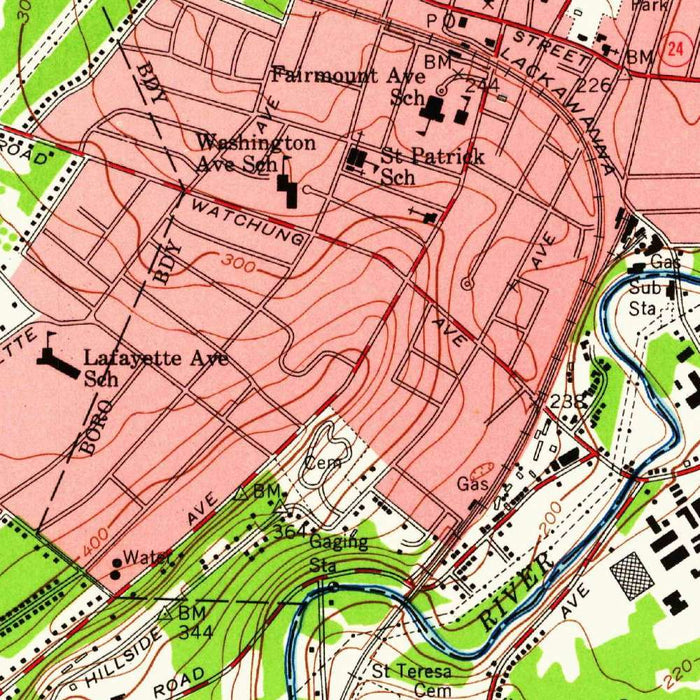
Published in 1961 from a map dated 1955, the United States Geological Survey’s “Chatham Quadrangle” presents a richly detailed portrait of northern New Jersey at a pivotal mid-century moment. Centered on Chatham and extending across portions of Morris and Essex Counties, it captures a landscape balanced between long-established town centers, commuter corridors, wooded hills, and expanding suburban neighborhoods. At the 1:24,000 scale, the map offers an intimate view of roads, railways, trails, streams, elevations, and civic features, making it both scientifically precise and historically evocative. It is a snapshot of Chatham and its environs before later waves of development further reshaped the region’s fields, forests, and residential patterns.
The map was produced by the United States Geological Survey, the federal agency whose topographic quadrangles became essential tools for engineers, planners, hikers, local governments, and historians. USGS maps are admired for their disciplined clarity: every symbol serves a purpose, every contour line contributes to an understanding of the land. In the “Chatham Quadrangle,” that tradition is especially compelling, as the agency’s standardized cartographic language reveals the structure of everyday terrain. The map transforms familiar communities into a precise geographic system, where street grids, railroad alignments, stream valleys, and wooded ridges can be read together as part of a larger environmental and human story.
Chatham appears here not merely as a town, but as a node within a broader regional fabric linking New Providence, Plainfield, and neighboring communities across county lines. Roads and railways underscore the area’s long-standing relationship with metropolitan New York, while smaller routes and trails suggest more local patterns of movement through residential districts, open land, and parkland. The built environment is carefully marked, yet it never overwhelms the natural one. Instead, the map reveals the layered character of mid-20th-century New Jersey: suburban growth spreading through older settlements, transportation networks knitting together towns, and pockets of green space still defining the experience of the landscape.
The topography is one of the map’s great pleasures. Light brown contour lines articulate the hills, valleys, and subtle undulations of the region, allowing the viewer to perceive the land’s physical drama even in a densely settled area. Green shading identifies forested tracts and parklands, offering a vivid counterpoint to the mapped roads and developed zones. Streams, lowlands, slopes, and ridgelines emerge with quiet precision, showing how settlement followed, crossed, and adapted to the natural terrain. This is the kind of map that rewards close looking, revealing how geography influenced the placement of neighborhoods, routes, open spaces, and civic infrastructure.
As a historical document, the “Chatham Quadrangle” preserves a moment when Morris and Essex Counties were undergoing significant transformation. The postwar decades brought accelerating suburbanization, new housing, expanded road use, and changing land use patterns across northern New Jersey. Against that backdrop, the map records a world in transition: recognizable modern communities set within a landscape that still retained visible traces of earlier rural and wooded character. For collectors, local historians, and those with ties to Chatham or its neighboring towns, it offers more than geographic information. It is an elegant cartographic record of place, memory, and change in mid-century America.
Cities, towns and places on this map
- Chatham, NJ
- New Providence, NJ
- Plainfield, NJ
- Morris County, NJ
- Essex County, NJ
- Roads, railways, and trails through the area
- Nearby parks and green spaces
- Features and man-made structures clearly marked
Historical context & cartographic details
- Produced by the United States Geological Survey (USGS)
- Historical 1:24,000 topographical map of Chatham, New Jersey and the surrounding area
- Map is dated 1955 and carries a 1961 imprint
- Reflects the geographical features and urban layout of the area during the mid-20th century
- Uses color coding, including green for forested areas and light brown for elevation
- Detailed topography is shown with contour lines illustrating hills, valleys, and elevation changes
- Documents the area before later urbanization and land-use changes transformed the landscape
- Valuable for historical, geographical, and local development reference
Looking for a particular place? Review the detailed images to confirm that the town, landmark or feature you have in mind appears on the map. If you are unsure, ask our workshop to check before you order.
Detailed maps are especially rewarding at larger sizes, where names, boundaries and decorative features have more room to be appreciated. Use the close-up preview and size guide to choose the right scale for your wall.
This map looks amazing at sizes all the way up to 50in (125cm). If you are looking for a larger map, please get in touch.
The model in the listing images is holding the 16x20in (40x50cm) version of this map.
Where personalisation is available, you can add a short title or dedication, mark one meaningful place, or request one considered visual detail. See personalised map examples.
Every piece is printed to museum-grade archival standards using fade-resistant pigment inks on acid-free matte paper. Choose an unframed map print, framed map or canvas using the finish options above. Framed maps use crystal-clear optical acrylic and arrive ready to hang.
With its rich detail and strong sense of place, this map makes a considered gift for a new home, anniversary, retirement or anyone with a personal connection to the area shown. Still deciding? Explore our collection of rare old and vintage maps to discover another place, period or style.
Share