The Unique Maps Co.
Map of Wolfeboro, New Hampshire by USGS, 1987 – Lake Wentworth, Tuftonboro & Crescent Lake
Map of Wolfeboro, New Hampshire by USGS, 1987 – Lake Wentworth, Tuftonboro & Crescent Lake
Couldn't load pickup availability
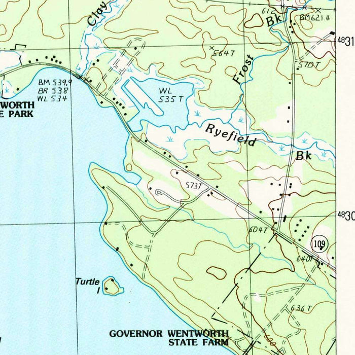
“Wolfeboro,” produced by the United States Geological Survey in 1987, presents one of New Hampshire’s most storied lake-country communities through the disciplined elegance of a 1:24,000 topographic quadrangle. Carrying a provisional designation, the map captures Wolfeboro and its surrounding terrain at a moment late in the twentieth century, when recreational development, historic village life, and the enduring geography of the Lakes Region converged. The title is spare, but the landscape it names is rich: a town long celebrated as the “Oldest Summer Resort in America,” set among sheltered bays, wooded hills, winding roads, and glittering inland waters. In the USGS tradition, the map balances scientific precision with quiet visual beauty, transforming elevation, shoreline, settlement, and forest into a refined cartographic portrait.
The United States Geological Survey, established in the nineteenth century, brought to maps like this a national mission: to measure, classify, and clarify the American landscape. By 1987, USGS topographic mapping had become an essential language for planners, hikers, engineers, geologists, and local historians alike. The Wolfeboro sheet reflects that legacy in its crisp hierarchy of color and line: blue waterways, brown contour intervals, black cultural features, and carefully marked roads and boundaries. Rather than dramatizing the land, the map lets the land speak through measured detail. Hills rise in rhythmic contouring, wetlands and streams thread through low ground, and human settlement appears as one layer within a much older natural framework.
At the heart of the map lies Wolfeboro, poised between Lake Wentworth, Crescent Lake, Back Bay, and the waterways that connect them. The town’s celebrated resort identity is inseparable from this aquatic setting, and the map makes clear why generations of summer visitors were drawn here. Lake Wentworth dominates the composition with its intricate shoreline and island-dotted surface, including features such as Lang Pond Island and Wills Island. Around it, small ponds, ephemeral streams, and wooded margins create a complex hydrological network typical of New Hampshire’s glaciated landscapes. Smith River and other watercourses further animate the sheet, linking upland drainage to the lake basins and revealing the subtle engineering of the region’s natural terrain.
The topographic character of the Wolfeboro area is rendered with particular clarity. Contour lines show a landscape of modest but persistent relief, where hills and ridges rise above lakes, marshes, and village roads. This is not a severe mountain terrain, but a varied and intimate one, shaped by ice, water, forest, and settlement. Roads such as Route 28 and local lanes curve through the mapped area, connecting Wolfeboro with Tuftonboro and the wider Lakes Region. Parks, forested tracts, scattered dwellings, and shoreline development are all encoded through the USGS symbol system, allowing the viewer to read both the recreational appeal and the practical geography of the area.
As a 1987 snapshot, “Wolfeboro” offers historical value beyond its immediate navigational purpose. It preserves the configuration of roads, settlement patterns, shorelines, wooded areas, and open spaces at a specific point in the late twentieth century, inviting comparison with the present-day landscape. In a region shaped by tourism, seasonal homes, conservation priorities, and changing patterns of land use, such a map becomes a subtle record of transition. Its appeal lies not only in the beauty of Wolfeboro and Lake Wentworth, but in the disciplined way the USGS captures place: every contour, island, road, stream, and pond contributing to a larger portrait of New Hampshire’s beloved Lakes Region.
Cities, towns and places on this map
- Wolfeboro
- Lake Wentworth
- Smith River
- Tuftonboro
- Crescent Lake
- Back Bay
- Several islands, including Lang Pond Island and Wills Island
- A portion of the Lakes Region of New Hampshire
- Route 28 and various local roads
- Parks and forests
- Bodies of water and water features, including ephemeral streams and ponds
- Contour lines indicating elevations
Historical context & cartographic details
- Produced by the United States Geological Survey as a historical 1:24,000 topographical map with a provisional designation.
- Created in 1987.
- Published by the United States Geological Survey, which has mapped the United States for over 140 years.
- Reflects the USGS tradition of providing mapping for navigation, geology, land use, and geographic reference.
- Wolfeboro is often referred to as the “Oldest Summer Resort in America,” with a history closely tied to tourism and recreation.
- Features clear, contrasting colors and detailed contour lines to represent elevation and terrain changes.
- Uses specific cartographic symbols to denote geographical features and landmarks.
- Shows varied New Hampshire terrain, including hills, wooded areas, lakes, ponds, and streams.
- May reveal changes in land use, urban development, and natural landscapes since the late 20th century.
Looking for a particular place? Review the detailed images to confirm that the town, landmark or feature you have in mind appears on the map. If you are unsure, ask our workshop to check before you order.
Detailed maps are especially rewarding at larger sizes, where names, boundaries and decorative features have more room to be appreciated. Use the close-up preview and size guide to choose the right scale for your wall.
This map looks amazing at sizes all the way up to 50in (125cm). If you are looking for a larger map, please get in touch.
The model in the listing images is holding the 16x20in (40x50cm) version of this map.
Where personalisation is available, you can add a short title or dedication, mark one meaningful place, or request one considered visual detail. See personalised map examples.
Every piece is printed to museum-grade archival standards using fade-resistant pigment inks on acid-free matte paper. Choose an unframed map print, framed map or canvas using the finish options above. Framed maps use crystal-clear optical acrylic and arrive ready to hang.
With its rich detail and strong sense of place, this map makes a considered gift for a new home, anniversary, retirement or anyone with a personal connection to the area shown. Still deciding? Explore our collection of rare old and vintage maps to discover another place, period or style.
Share