The Unique Maps Co.
Map of North Conway, New Hampshire by USGS, 1995 – White Mountain National Forest & Saco River
Map of North Conway, New Hampshire by USGS, 1995 – White Mountain National Forest & Saco River
Couldn't load pickup availability
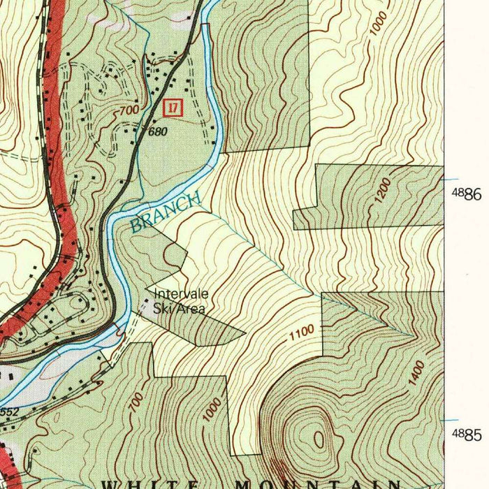
Published in a 2000 imprint from the 1995 USGS topographic edition, “North Conway West” presents one of New Hampshire’s most storied mountain landscapes with the disciplined clarity of a 1:24,000 quadrangle. Centered on North Conway and its western approaches, the map captures the meeting of village life, resort culture, and rugged upland terrain at the edge of the White Mountain National Forest. Roads such as Route 302 and Route 16 thread through the settled valleys, while contour lines tighten dramatically around Moat Mountain, Mount Cranmore, and Kearsarge North. The result is a richly informative portrait of a place long cherished by hikers, skiers, climbers, and travelers drawn to the dramatic scenery of the Saco River valley.
The U.S. Geological Survey brings to this map the understated authority that made its quadrangles essential tools for scientists, land managers, engineers, and outdoor explorers. Founded in 1879, the USGS became the nation’s principal cartographic and earth-science agency, translating field surveys, aerial photography, hydrography, and elevation data into maps of remarkable precision. Here, its visual language is both technical and elegant: brown contour lines describe every rise and ravine, blue tracery marks streams, ponds, and lakes, and black and red symbols clarify roads, buildings, boundaries, and public facilities. In an area where small changes in elevation can transform a gentle walk into a mountain ascent, the USGS style gives the landscape a legible, almost architectural structure.
North Conway itself anchors the map, a village whose identity has long been shaped by the White Mountains rising around it. The map shows the community not as an isolated resort town, but as part of a larger geographical system: the Saco River bending through the valley, Intervale to the north, Conway Lake and Emerald Lake nearby, and forested slopes climbing toward the Presidential and Sandwich ranges beyond the sheet’s immediate focus. Mount Cranmore appears as both a landmark and a reminder of the region’s skiing heritage, while Moat Mountain and Kearsarge North speak to the older appeal of ridge walks, fire towers, and expansive views across northern New England.
The surrounding White Mountain National Forest gives the map much of its depth and historical resonance. Established in the early twentieth century after widespread logging and watershed damage, the forest became a landmark experiment in conservation, recreation, and federal land stewardship. This quadrangle records that legacy in the fine detail of trails, forest roads, drainage lines, and protected terrain. Bear Notch Road, Passaconaway Mountain, and the network of recreational paths point toward a landscape increasingly managed for public access as well as ecological resilience. The topography reveals why this region demanded careful management: steep slopes, narrow valleys, fast-running waters, and highland forests form a terrain both beautiful and vulnerable.
As a historical document, “North Conway West” captures the area at a moment when outdoor recreation, tourism, residential development, and conservation were all reshaping the Mount Washington Valley. The map’s roads and settlement patterns show how North Conway had grown into a year-round destination, connected by major regional routes yet still closely bounded by mountains and forest. At the same time, the fine-grained depiction of water bodies such as Conway Lake, Nequasset Lake, and the Saco River preserves the hydrological framework that underlies local ecology and land use. For anyone drawn to the White Mountains, this map offers more than orientation: it is a precise, quietly beautiful record of a celebrated New Hampshire landscape.
Cities, towns and places on this map
- North Conway
- White Mountain National Forest
- Saco River
- Conway Lake
- Moat Mountain
- Mount Cranmore
- Kearsarge North
- Route 302
- Route 16
- Nequasset Lake
- Bear Notch Road
- Emerald Lake
- Passaconaway Mountain
- Intervale
- Various hiking trails and recreational paths within the area
Historical context & cartographic details
- Produced by the U.S. Geological Survey, this historical 1:24,000 topographical map shows North Conway, New Hampshire, and the surrounding area.
- The map is dated 1995 and carries a 2000 imprint.
- Created by the U.S. Geological Survey, a respected agency known for scientific assessments and mapping services across the United States.
- Features classic USGS topographical elements, including contour lines indicating elevation changes, water bodies, and marked trails.
- Characterized by a clear, functional cartographic design.
- Shows varied terrain, including mountain peaks, valleys, and water features typical of the New Hampshire landscape.
- Reflects changes over time in land use, development, and natural resource management in the North Conway area.
- Highlights the conservation context of the White Mountain National Forest.
Looking for a particular place? Review the detailed images to confirm that the town, landmark or feature you have in mind appears on the map. If you are unsure, ask our workshop to check before you order.
Detailed maps are especially rewarding at larger sizes, where names, boundaries and decorative features have more room to be appreciated. Use the close-up preview and size guide to choose the right scale for your wall.
This map looks amazing at sizes all the way up to 50in (125cm). If you are looking for a larger map, please get in touch.
The model in the listing images is holding the 16x20in (40x50cm) version of this map.
Where personalisation is available, you can add a short title or dedication, mark one meaningful place, or request one considered visual detail. See personalised map examples.
Every piece is printed to museum-grade archival standards using fade-resistant pigment inks on acid-free matte paper. Choose an unframed map print, framed map or canvas using the finish options above. Framed maps use crystal-clear optical acrylic and arrive ready to hang.
With its rich detail and strong sense of place, this map makes a considered gift for a new home, anniversary, retirement or anyone with a personal connection to the area shown. Still deciding? Explore our collection of rare old and vintage maps to discover another place, period or style.
Share