The Unique Maps Co.
Map of Lake Winnipesaukee, New Hampshire by USGS, 1987 – West Alton, Gilford & Wolfeboro
Map of Lake Winnipesaukee, New Hampshire by USGS, 1987 – West Alton, Gilford & Wolfeboro
Couldn't load pickup availability
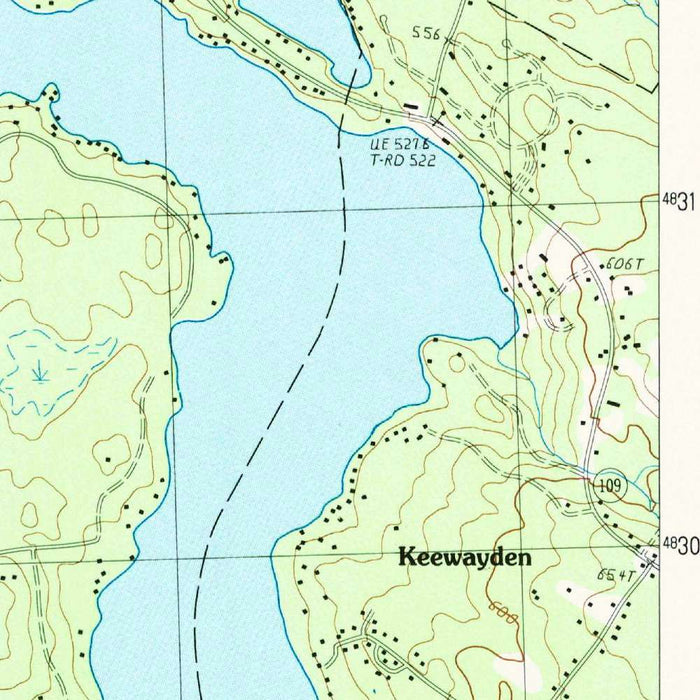
Published in 1987 by the United States Geological Survey, the map titled “West Alton, New Hampshire” captures a richly detailed portion of the Lakes Region at a moment when traditional topographic cartography remained the authoritative language of American landscape study. Issued as a provisional map, it reflects the USGS practice of circulating highly useful geographic information while acknowledging that later revision or refinement might follow. At the precise 1:24,000 scale, the sheet offers an intimate reading of terrain: shorelines, roads, trails, elevations, wooded slopes, and settled places are all rendered with scientific discipline. Its focus is the dramatic meeting of land and water around Lake Winnipesaukee, where islands, coves, ridges, and lakeside communities create one of New Hampshire’s most memorable topographic settings.
Lake Winnipesaukee dominates the composition, its broad blue expanse interrupted by the distinctive forms of Bear Island, Long Island, Rattlesnake Island, Mark Island, and numerous smaller shoreline features. The lake, New Hampshire’s largest, has long been a center of travel, recreation, summer settlement, and regional identity, and this map presents it not merely as scenery but as a navigable, inhabited landscape. The intricate shoreline reveals bays, peninsulas, and narrow passages that have shaped local movement and development for generations. West Alton appears within this waterside geography, connected by roads and terrain to neighboring Gilford, Tuftonboro, and Wolfeboro. The map’s close attention to the lake’s margins makes it especially evocative of a place where geography governs community life.
The US Geological Survey’s topographic style gives the map its enduring elegance and usefulness. Contour lines articulate the rise and fall of the land with quiet precision, transforming hills, valleys, and ridgelines into a readable visual rhythm. Greens indicate wooded and vegetated terrain, while blues define the lakes, streams, and wetland features that give the region its character. The surrounding Belknap Range provides a strong topographic counterpoint to Lake Winnipesaukee’s open waters, with elevations and slopes revealing the ruggedness beyond the shoreline. Loon Mountain and other local heights appear within this measured landscape, while roads and trails trace human routes through natural contours. The result is a map that is both technical document and portrait of place.
The communities shown—Gilford, Tuftonboro, Wolfeboro, and West Alton—belong to a historic Lakes Region landscape shaped by tourism, seasonal residence, forestry, small-scale settlement, and access to water. By 1987, Lake Winnipesaukee was already famous for boating, fishing, summer cottages, resorts, and scenic drives, yet the map preserves a quieter structural view beneath those associations. Roads bend around hills and coves, trails move through uplands, and development gathers where terrain permits. For collectors, this date is especially interesting: it records the region before later decades of intensified shoreline development, changing land use, and evolving conservation priorities. In that sense, the map offers a snapshot of late twentieth-century New Hampshire, poised between rural continuity and recreational expansion.
As a USGS provisional topographic map, “West Alton, New Hampshire” belongs to a distinguished cartographic tradition grounded in field observation, aerial survey, and standardized national mapping. The agency’s work has long served engineers, hikers, planners, scientists, landowners, and historians, and this sheet demonstrates why: it synthesizes natural and human geography with remarkable clarity. Every contour, road, island, and shoreline helps reconstruct the lived landscape of the Winnipesaukee basin. Its appeal lies not only in its geographic specificity, but also in the way it reveals the relationship between water, mountain, settlement, and movement. For anyone drawn to New Hampshire’s Lakes Region, this map is a finely observed record of one of the state’s most beloved landscapes.
Cities, towns and places on this map
- Lake Winnipesaukee
- West Alton
- Gilford
- Tuftonboro
- Wolfeboro
- Bear Island
- Long Island
- Rattlesnake Island
- Mark Island
- The Belknap Range
- Loon Mountain
- Several trails and roads in the surrounding area
- Various contours and elevation points indicating topographic features across the map
Historical context & cartographic details
- Produced by the US Geological Survey as a provisional map
- Published in 1987
- Created by the US Geological Survey, a U.S. federal scientific agency known for authoritative geographic and geological maps
- Features Lake Winnipesaukee, New Hampshire’s largest lake and a significant recreational area
- Uses a traditional topographic style with contour lines to show elevation changes
- Includes green and blue color schemes to distinguish land and water features
- Drawn at a detailed 1:24,000 scale, showing hills, valleys, water bodies, and other topographic features
- May document land use and landscape features that have changed since 1987 due to development, environmental change, or shifts in land ownership and usage patterns
Looking for a particular place? Review the detailed images to confirm that the town, landmark or feature you have in mind appears on the map. If you are unsure, ask our workshop to check before you order.
Detailed maps are especially rewarding at larger sizes, where names, boundaries and decorative features have more room to be appreciated. Use the close-up preview and size guide to choose the right scale for your wall.
This map looks amazing at sizes all the way up to 50in (125cm). If you are looking for a larger map, please get in touch.
The model in the listing images is holding the 16x20in (40x50cm) version of this map.
Where personalisation is available, you can add a short title or dedication, mark one meaningful place, or request one considered visual detail. See personalised map examples.
Every piece is printed to museum-grade archival standards using fade-resistant pigment inks on acid-free matte paper. Choose an unframed map print, framed map or canvas using the finish options above. Framed maps use crystal-clear optical acrylic and arrive ready to hang.
With its rich detail and strong sense of place, this map makes a considered gift for a new home, anniversary, retirement or anyone with a personal connection to the area shown. Still deciding? Explore our collection of rare old and vintage maps to discover another place, period or style.
Share