The Unique Maps Co.
Map of Cuchara, Colorado by USGS, 1994 – Spanish Peaks, La Veta Pass & San Isabel National Forest
Map of Cuchara, Colorado by USGS, 1994 – Spanish Peaks, La Veta Pass & San Isabel National Forest
Couldn't load pickup availability
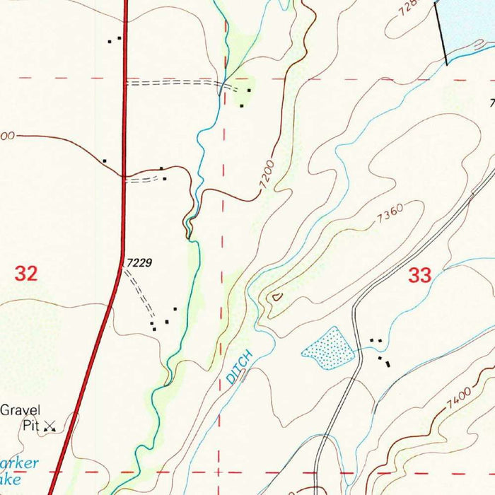
Published in 2001 from survey data gathered in 1994, the US Geological Survey’s “Cuchara” presents a finely observed portrait of one of southern Colorado’s most evocative mountain settings. At the 1:24,000 scale, the map brings the Cuchara Valley into close focus, revealing the relationship between settlement, water, forest, and elevation with the disciplined clarity that defines USGS topographic work. The populated place of Cuchara appears within a dramatic landscape shaped by ridges, drainages, and steeply rising terrain. Closely spaced contour lines immediately communicate the rugged character of the area, while the restrained USGS color palette distinguishes woodland, public land, routes, and relief. It is a map of both practical precision and quiet grandeur, capturing a high-country community at the turn of the twenty-first century.
The US Geological Survey, established in 1879, became one of the great cartographic institutions of the modern United States, transforming field measurement and scientific observation into authoritative national mapping. Its topographic quadrangles are prized not only for utility but for their remarkable consistency: every contour, stream course, road, and symbol contributes to a legible geographic system. In “Cuchara,” that tradition is evident in the exact rendering of slopes, valleys, trails, and forested zones around the Spanish Peaks region. Rather than embellishment, the beauty of the map lies in its rigor. The USGS style allows the viewer to read the land almost as a three-dimensional form, following ridgelines, creek beds, passes, and human pathways across a landscape where elevation is the defining fact.
The geography shown here is dominated by the mountainous terrain surrounding Cuchara and the broader Cuchara Valley, a place long valued for its alpine atmosphere, wooded slopes, and proximity to the Spanish Peaks. The map’s contouring conveys the steepness of the surrounding hills with striking immediacy, especially where lines gather tightly along the flanks of ridges and drainages. Cuchara River and nearby waterways, including Boulder Creek and the Huerfano River system, give structure to the land, tracing the corridors through which roads, trails, and settlement naturally follow. La Veta Pass anchors the wider regional context, a historic crossing through the mountains that links this intimate valley landscape to the larger movement of people, commerce, and exploration across southern Colorado.
San Isabel National Forest forms an important presence on the map, its public lands and wooded areas marking Cuchara as part of a larger mountain ecology. The cartography distinguishes these forested and designated areas with the familiar language of USGS mapping, allowing the viewer to see where human habitation gives way to public land, trail systems, and wilder terrain. Trails and route corridors thread through the hills, suggesting recreational access as well as older patterns of movement through the landscape. U.S. Highway 350 and other regional roads provide orientation within a terrain that is otherwise defined by elevation and drainage. This interplay between engineered routes and natural relief is one of the pleasures of the map, showing how infrastructure adapts to the shape of the mountains.
As a historical topographic record, “Cuchara” preserves a moment in the development and environmental history of southern Colorado. Since the 1994 survey and 2001 imprint, mountain communities such as Cuchara have continued to evolve through changing land use, tourism, conservation priorities, and shifting patterns of rural development. The map therefore offers more than geographic reference; it is a carefully dated snapshot of roads, trails, public lands, waterways, and settlement at a specific point in time. Its close-scale rendering makes visible the delicate balance between a small populated place and the powerful surrounding landscape. For collectors, historians, and admirers of Colorado’s high country, it is an elegant record of Cuchara’s position within one of the state’s most distinctive mountain regions.
Cities, towns and places on this map
- Cuchara
- La Veta Pass
- Spanish Peaks
- Cuchara Valley
- Huerfano River
- Cuchara River
- U.S. Highway 350
- San Isabel National Forest
- Woodlands
- Trails
- Boulder Creek
- Various contour elevations
- Public lands and designated areas in the San Isabel National Forest
Historical context & cartographic details
- Produced by the US Geological Survey, this historical 1:24,000 topographical map uses survey data from 1994 and carries a 2001 imprint.
- Created in 1994 and published in 2001.
- Published by the US Geological Survey, a scientific agency of the U.S. government known for mapping, analysis, and geographic data.
- The USGS has provided credible geospatial information since its establishment in 1879.
- The map uses contour lines in varying shades to represent elevation and terrain relief.
- A distinct USGS color scheme denotes land uses and elevations.
- Closely spaced contour lines indicate hilly and mountainous terrain with steep slopes.
- The map serves as a historical record of the area before later urban, environmental, or land-use changes.
Looking for a particular place? Review the detailed images to confirm that the town, landmark or feature you have in mind appears on the map. If you are unsure, ask our workshop to check before you order.
Detailed maps are especially rewarding at larger sizes, where names, boundaries and decorative features have more room to be appreciated. Use the close-up preview and size guide to choose the right scale for your wall.
This map looks amazing at sizes all the way up to 50in (125cm). If you are looking for a larger map, please get in touch.
The model in the listing images is holding the 16x20in (40x50cm) version of this map.
Where personalisation is available, you can add a short title or dedication, mark one meaningful place, or request one considered visual detail. See personalised map examples.
Every piece is printed to museum-grade archival standards using fade-resistant pigment inks on acid-free matte paper. Choose an unframed map print, framed map or canvas using the finish options above. Framed maps use crystal-clear optical acrylic and arrive ready to hang.
With its rich detail and strong sense of place, this map makes a considered gift for a new home, anniversary, retirement or anyone with a personal connection to the area shown. Still deciding? Explore our collection of rare old and vintage maps to discover another place, period or style.
Share