The Unique Maps Co.
Map of Crestone, Colorado by USGS, 2001 – Great Sand Dunes National Park & Sangre de Cristo Mountains
Map of Crestone, Colorado by USGS, 2001 – Great Sand Dunes National Park & Sangre de Cristo Mountains
Couldn't load pickup availability
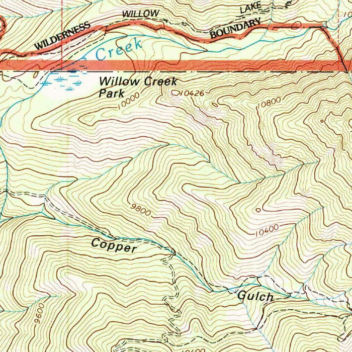
Published in 2005 from 2001 survey data, the US Geological Survey’s “Crestone” captures one of Colorado’s most dramatic meetings of mountain, desert, and valley. At 1:24,000 scale, it presents the town of Crestone and its surroundings with the disciplined precision of classic USGS topography: contour lines gather tightly across the Sangre de Cristo Mountains, then relax westward toward the broad floor of the San Luis Valley. The result is a richly legible portrait of a landscape defined by extremes—high alpine ridges, arid basins, braided drainages, and the nearby immensity of Great Sand Dunes National Park. More than a practical survey, the map records a distinctive moment in the region’s cultural and environmental history at the turn of the twenty-first century.
The mapmaker, the United States Geological Survey, brings to this sheet more than a century of scientific cartographic authority. Founded in 1879, the USGS became the nation’s principal interpreter of terrain, geology, water, and natural resources, producing maps that shaped exploration, land management, conservation, and development across the American West. In the “Crestone” quadrangle, that institutional tradition is visible in every measured contour, road classification, watercourse, and boundary line. The map’s clean symbology and meticulous elevation modeling reflect the USGS ideal: to make the land intelligible without diminishing its complexity. For collectors, this sheet belongs to a lineage of federal mapping that transformed remote mountain valleys and rugged wilderness approaches into carefully documented geographic knowledge.
Crestone itself occupies a singular place in Colorado geography and culture. Nestled below the western flank of the Sangre de Cristo Mountains, the town is small in scale but unusually resonant in reputation, known for its contemplative communities, retreat centers, and spiritual institutions. Nearby Baca Grande appears as part of the human pattern laid over this austere terrain, with roads and tracks edging into the foothills and open valley. The map quietly juxtaposes settlement with vastness: named roads, Forest Service routes, and trails thread outward into a landscape where peaks, drainages, and public lands dominate the visual field. It is this tension—between human intention and mountainous grandeur—that gives the Crestone area much of its enduring fascination.
The surrounding natural features are among the most striking in the southern Rockies. The Sangre de Cristo Mountains rise abruptly from the San Luis Valley, their steep slopes rendered through dense contouring that conveys both height and severity. Features such as Sheep Mountain, Blanca Peak, and the high ridgelines of the range evoke the alpine world just east of Crestone, while the Huerfano River, Medano Creek, and numerous smaller creeks mark the vital movement of water through an otherwise dry region. To the southwest, the presence of Great Sand Dunes National Park and Dunes Park introduces an extraordinary geomorphic contrast: towering dunes formed by wind, sediment, mountain runoff, and valley-floor conditions, set against snow-fed peaks.
Cartographically, “Crestone” is a fine example of late twentieth- and early twenty-first-century USGS topographic design. Its contour intervals give sculptural clarity to the land, allowing the reader to perceive slopes, ridges, ravines, valley bottoms, and passes almost intuitively. Road and trail networks, including Loop Road and various Forest Service Roads, reveal patterns of access into a region valued for wilderness, recreation, ranching, and spiritual retreat. Boundaries and natural symbols place the map within a broader story of land stewardship, especially around Great Sand Dunes National Park and the surrounding public lands. As a historical document, it preserves the Crestone landscape as mapped in 2001, offering a precise record of terrain and settlement before subsequent environmental, recreational, and community changes unfolded.
Cities, towns and places on this map
- Crestone, Colorado
- Great Sand Dunes National Park
- Blanca Peak
- Sheep Mountain
- Huerfano River
- Medano Creek
- San Luis Valley
- Sangre de Cristo Mountains
- Dunes Park
- Baca Grande
- Loop Road
- Forest Service Roads
- Trails
- Various unnamed water bodies and creeks
Historical context & cartographic details
- Produced by the US Geological Survey, this historical 1:24,000 topographical map shows Crestone in Colorado and the surrounding area.
- The map is dated 2001 and carries a 2005 imprint.
- The US Geological Survey is a scientific agency of the U.S. federal government responsible for studying the landscape, natural resources, and natural hazards of the United States.
- The USGS has a long history dating back to 1879 and has played a pivotal role in mapping and providing data on U.S. geology and natural resources.
- Crestone is known for its unique spiritual community and its proximity to major natural features in southern Colorado.
- The map uses classic USGS styling, including contour lines to show elevation changes, road and trail networks, and shaded relief to depict topography.
- The topography highlights rugged Colorado terrain, with detailed elevation contours, peaks, valleys, and natural features.
- As a turn-of-the-century land record, the map offers insight into the natural and cultural landscape of the area at the time of publication.
Looking for a particular place? Review the detailed images to confirm that the town, landmark or feature you have in mind appears on the map. If you are unsure, ask our workshop to check before you order.
Detailed maps are especially rewarding at larger sizes, where names, boundaries and decorative features have more room to be appreciated. Use the close-up preview and size guide to choose the right scale for your wall.
This map looks amazing at sizes all the way up to 50in (125cm). If you are looking for a larger map, please get in touch.
The model in the listing images is holding the 16x20in (40x50cm) version of this map.
Where personalisation is available, you can add a short title or dedication, mark one meaningful place, or request one considered visual detail. See personalised map examples.
Every piece is printed to museum-grade archival standards using fade-resistant pigment inks on acid-free matte paper. Choose an unframed map print, framed map or canvas using the finish options above. Framed maps use crystal-clear optical acrylic and arrive ready to hang.
With its rich detail and strong sense of place, this map makes a considered gift for a new home, anniversary, retirement or anyone with a personal connection to the area shown. Still deciding? Explore our collection of rare old and vintage maps to discover another place, period or style.
Share